
They're consistent but not very close to each other.
They're consistent but not very close to each other.
The results of my distortion mapping work below. Note that, especially for 06, there are a LOT of cases where no beam locations correction (noBL) had a higher peak than the distortion corrected map. I have no explanation for this yet. More work to come...
PEAK COMPARISON BL: 5.95824 noBL: 3.09836 uranus_050619_o23 PEAK COMPARISON BL: 3.93725 noBL: 2.85479 uranus_050619_o24 PEAK COMPARISON BL: 15.5613 noBL: 523.035 neptune_050626_o19 PEAK COMPARISON BL: 16.4601 noBL: 16.0038 neptune_050626_o20 PEAK COMPARISON BL: 426.671 noBL: 375.174 mars_050627_o31 PEAK COMPARISON BL: 415.968 noBL: 413.327 mars_050627_o32 PEAK COMPARISON BL: 15.2464 noBL: 33.8593 uranus_050628_o33 PEAK COMPARISON BL: 34.6631 noBL: 35.5086 uranus_050628_o34 PEAK COMPARISON BL: 164.832 noBL: 403.189 uranus_050904_o31 PEAK COMPARISON BL: 216.820 noBL: 425.613 uranus_050904_o32 PEAK COMPARISON BL: 134.972 noBL: 156.196 uranus_050911_ob8 PEAK COMPARISON BL: 11.0957 noBL: 11.1993 neptune_060602_o30 PEAK COMPARISON BL: 12.0000 noBL: 11.0947 neptune_060602_o31 PEAK COMPARISON BL: 2478.20 noBL: 2365.17 mars_060605_ob1 PEAK COMPARISON BL: 2144.68 noBL: 2147.18 mars_060605_ob2 PEAK COMPARISON BL: 17.7354 noBL: 25.7041 uranus_060621_o29 PEAK COMPARISON BL: 18.7889 noBL: 25.6599 uranus_060621_o30 PEAK COMPARISON BL: 28.1957 noBL: 31.1013 uranus_060625_o46 PEAK COMPARISON BL: 23.0236 noBL: 27.8556 uranus_060905_ob6 PEAK COMPARISON BL: 18.8731 noBL: 28.4964 uranus_060906_o12 PEAK COMPARISON BL: 23.3481 noBL: 29.8294 uranus_060908_o13 PEAK COMPARISON BL: 20.6238 noBL: 26.9424 uranus_060909_o12 PEAK COMPARISON BL: 21.1049 noBL: 28.8533 uranus_060910_o12 PEAK COMPARISON BL: 24.0231 noBL: 32.0877 uranus_060914_o10 PEAK COMPARISON BL: 23.2590 noBL: 33.3496 uranus_060914_o11 PEAK COMPARISON BL: 24.0538 noBL: 30.0552 uranus_060919_ob9 PEAK COMPARISON BL: 355.467 noBL: 669.416 g34.3_070630_o34 PEAK COMPARISON BL: 246.803 noBL: 296.252 g34.3_070630_o35 PEAK COMPARISON BL: 724.874 noBL: 807.152 uranus_070702_o42 PEAK COMPARISON BL: 7.60370 noBL: 9.02960 uranus_070912_o27 PEAK COMPARISON BL: 98.8058 noBL: 88.9957 mars_070913_o22 PEAK COMPARISON BL: 82.2708 noBL: 89.3476 mars_070913_o23
pinned down the problem. Was a minor sign error in the offsets. Why is it that simple sign errors are ALWAYS the hardest things to track down? Now, open question: should x,y scaling be free parameters or not? What I mean is, when I measure the positions of bolometers on the array using the planet map, should I allow the X and Y stretch (the bolometer spacing) to change? Should it be a uniform stretch in X and Y or should it be allowed to 'distort' too? My opinion is, none of the above: I'm measuring their actual positions (in terms of a fixed spacing) and therefore stretching or distorting to match the nominal positions is not necessary.
Mars using uranus_070702_o42 distortion map:
BL070706_o38_raw_ds1.nc_indiv0 134.8757324 -0.2325330 0.0721872 3282.5439453 2.0985703 2.1959550 3147.6682129 2.3311033 2.1237679BL070706_o39_raw_ds1.nc_indiv0 188.0588379 -0.0947621 -0.0643225 3782.3984375 2.1416662 1.9909470 3594.3395996 2.2364283 2.0552695BL070706_o40_raw_ds1.nc_indiv0 451.6955566 -0.0427303 -0.3303463 3461.9191895 2.1925442 2.0726480 3010.2236328 2.2352746 2.4029944BL070713_o36_raw_ds1.nc_indiv0 294.5898438 -0.2068889 0.0493107 5975.9482422 1.9935303 2.1527038 5681.3583984 2.2004192 2.1033931BL070713_o37_raw_ds1.nc_indiv0 813.5678711 -0.4597032 0.0361557 5515.4501953 2.0334179 2.1772604 4701.8823242 2.4931211 2.1411047BL070713_o38_raw_ds1.nc_indiv0 286.2934570 -0.1904230 0.0520797 5967.7011719 1.9853363 2.1624830 5681.4077148 2.1757593 2.1104033BL070713_o39_raw_ds1.nc_indiv0 773.2104492 -0.0816238 -0.3387871 5409.8344727 2.0317609 2.1736624 4636.6240234 2.1133847 2.5124495BL070714_o76_raw_ds1.nc_indiv0 244.2031250 -0.2079357 0.0572422 5312.0419922 1.9982606 2.1597764 5067.8388672 2.2061963 2.1025343BL070714_o77_raw_ds1.nc_indiv0 688.7365723 -0.1176772 -0.3138330 4706.1503906 2.0379941 2.1989338 4017.4138184 2.1556714 2.5127668BL070715_o45_raw_ds1.nc_indiv0 108.5583496 -0.0652246 -0.0818899 2397.9819336 2.1608708 1.9907858 2289.4235840 2.2260954 2.0726757BL070715_o46_raw_ds1.nc_indiv0 268.4321289 -0.2927990 -0.0692098 2236.4533691 2.1387808 2.0159581 1968.0212402 2.4315798 2.0851679BL070717_o47_raw_ds1.nc_indiv0 372.6528320 -0.2188239 0.0690587 7070.0649414 1.9820960 2.1670835 6697.4121094 2.2009199 2.0980248BL070717_o48_raw_ds1.nc_indiv0 498.4628906 -0.2993519 0.0410304 6636.1396484 2.0418782 2.1088474 6137.6767578 2.3412302 2.0678170BL070718_o41_raw_ds1.nc_indiv0 287.1591797 -0.2016468 0.0641356 6684.1699219 1.9891322 2.1470959 6397.0107422 2.1907790 2.0829604BL070718_o42_raw_ds1.nc_indiv0 841.6083984 -0.0809386 -0.3511798 5934.2832031 2.0332539 2.1427581 5092.6748047 2.1141925 2.4939380BL070725_o34_raw_ds1.nc_indiv0 245.6381836 -0.0810674 -0.0582435 5918.6728516 1.9807132 2.1547492 5673.0346680 2.0617807 2.2129927BL070725_o35_raw_ds1.nc_indiv0 697.7910156 0.1512802 -0.6174591 4873.1469727 2.3222449 2.0499101 4175.3559570 2.1709647 2.6673691BL070726_o33_raw_ds1.nc_indiv0 216.2124023 -0.0697458 -0.0627950 5056.3364258 2.1531394 1.9873902 4840.1240234 2.2228851 2.0501852BL070726_o34_raw_ds1.nc_indiv0 433.0415039 -0.0154374 -0.3017542 4586.9204102 2.1483676 2.0385454 4153.8789062 2.1638050 2.3402996BL070730_o23_raw_ds1.nc_indiv0 105.4489746 0.1025155 -0.2241490 2679.8452148 2.1567283 1.9786894 2574.3962402 2.0542128 2.2028384BL070730_o24_raw_ds1.nc_indiv0 440.7482910 -0.3968222 -0.0447321 2595.1044922 2.0618360 2.1782801 2154.3562012 2.4586582 2.2230122
So, despite the fact that I clearly have a distortion mapper working, applying the distortion maps that come out of it do NOT improve the peak or FWHM of the data.
to do: histogram per square degree, plot cumulative > some bin number (100 mJy, 300 mJy, 1 Jy) vs l, then do it again for b=+/-.1, +/-.3.
Between sign errors, failures to fit, and.... I really don't know WHAT was going on, I finally figured out how to get the cursed distortion mapping to work. I still haven't even started testing, unfortunately. I don't know why I can fit the way the OP did, fitting R and Theta, and I apparently can't fit x,y. It's frustrating.
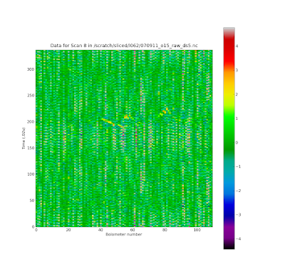
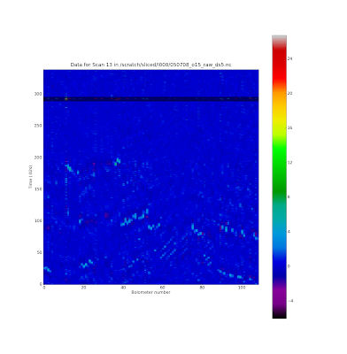
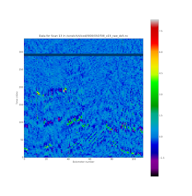
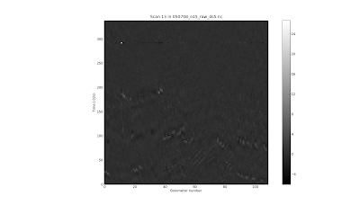
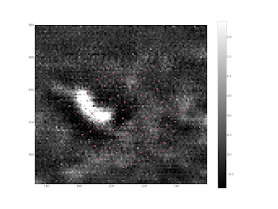
James requested sample images from the flagger for the methods paper. Below are images + description: .. image:: http://3.bp.blogspot.com/_lsgW26mWZnU/SXHsZcqegtI/AAAAAAAAEs4/3PjUtU2IXtQ/s400/sample_waterfall_070911_o15_highFnoisepng.png This is a "noise-dominated" scan in the sense that the high/low pixels are set by noise, not signal. Despite the clear high frequency noise, this image actually maps out pretty well - I think the high-noise bolometers get downweighted and the high/low pixels probably get clipped by my hot pixel rejection procedure. .. image:: http://3.bp.blogspot.com/_lsgW26mWZnU/SXHsY7Rgq3I/AAAAAAAAEsY/0NT8IB26JUo/s400/flagger_marked_source_050708_o15.png An image of the galactic center with a source southeast of center identified. .. image:: http://1.bp.blogspot.com/_lsgW26mWZnU/SXHsYyHCEGI/AAAAAAAAEsg/3iwoklY0--0/s400/sample_waterfall_050708_o15_glitchandsources.png A scan from the GC image above. I forgot to mark the source, I should go back and do that. The glitch is obvious. .. image:: http://1.bp.blogspot.com/_lsgW26mWZnU/SXHsZHVZ4OI/AAAAAAAAEso/pOXwGFn7rGg/s400/sample_waterfall_050708_o15_glitchflagged.png I drew a box to flag out the region affected by the glitch. .. image:: http://4.bp.blogspot.com/_lsgW26mWZnU/SXHsZG_MmWI/AAAAAAAAEsw/RA6tqAWMnLM/s400/sample_waterfall_050708_o15_glitchgone.png This is what happens when I redraw after flagging out the glitch - the colorbar is rescaled and no more glitch. .. image:: http://4.bp.blogspot.com/_lsgW26mWZnU/SXIDILh3hfI/AAAAAAAAEtQ/cMuOhlFO_fA/s400/sample_waterfall_050708_o15_glitchandsources_marked.png Timestream with glitches and sources marked (one pixel in the map is hit by 3 different points in this scan). .. image:: http://4.bp.blogspot.com/_lsgW26mWZnU/SXIDH3uIjHI/AAAAAAAAEtI/vijTeEWf_nA/s400/sample_waterfall_050708_o15_glitchandsources_gray.png Grayscale version of above (ok, I lied about grayscale being impossible) with a different pixel marked. .. image:: http://1.bp.blogspot.com/_lsgW26mWZnU/SXIDHbYLbiI/AAAAAAAAEtA/nSh2rM6GhMc/s400/flagger_marked_source_footprint_050708_o15.png A zoom-in around the 'kidney bean' source with the Bolocam footprint overlaid and a pixel marked. Note that this pixel corresponds to the 3 points in the color waterfall above.
0709 11-13 needed to be 83.88 degrees, they're all fixed now. I flagged the l060 070911 maps; I'm not convinced that was weather, there were some fluctuations up to 2400 Jy! Maybe a cloud would do that though.
Problems in the latest run:
l359 - missing files?
Reading files from /scratch/sliced/INFILES/l359\_infile.txt
FIELD v0.7\_l359 BEGUN at Fri Jan 16 20:11:34 2009
MRDFITS: File access error
% HEULER: ERROR - First parameter must be a FITS header or astrometry
 structure
l012 - missing files?
% READFITS: ERROR - Unable to locate file
 /scratch/adam\_work/l012/060614\_o10\_raw\_ds5.nc\_indiv13pca\_map01.fi
 ts
the l060-l062 range has some severe noise problems and rotator issues. They need to be fixed before release.